Napa Valley Vine Trail
The Napa Valley Vine Trail is a 47-mile contiguous protected bike and pedestrian path that will one day run from Calistoga to Vallejo. The Napa Valley Vine Trail Coalition is leading the effort with local cities and the County of Napa, having recently opened the section from Vallejo-to-American Canyon. Next up, partners are working to build the segment from Yountville-to St. Helena. NVTA led construction efforts on the Calistoga-to-St. Helena section, which opened in Aug. 2024.
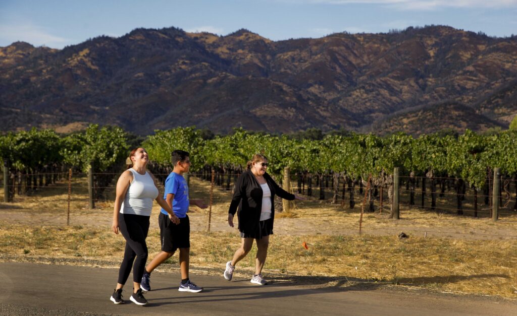
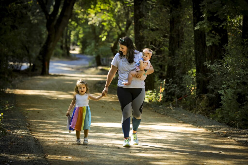
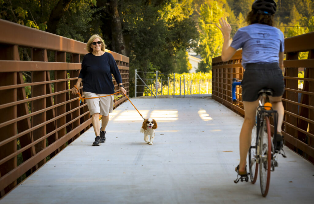
Photos: Napa Valley Vine Trail St. Helena-to-Calistoga

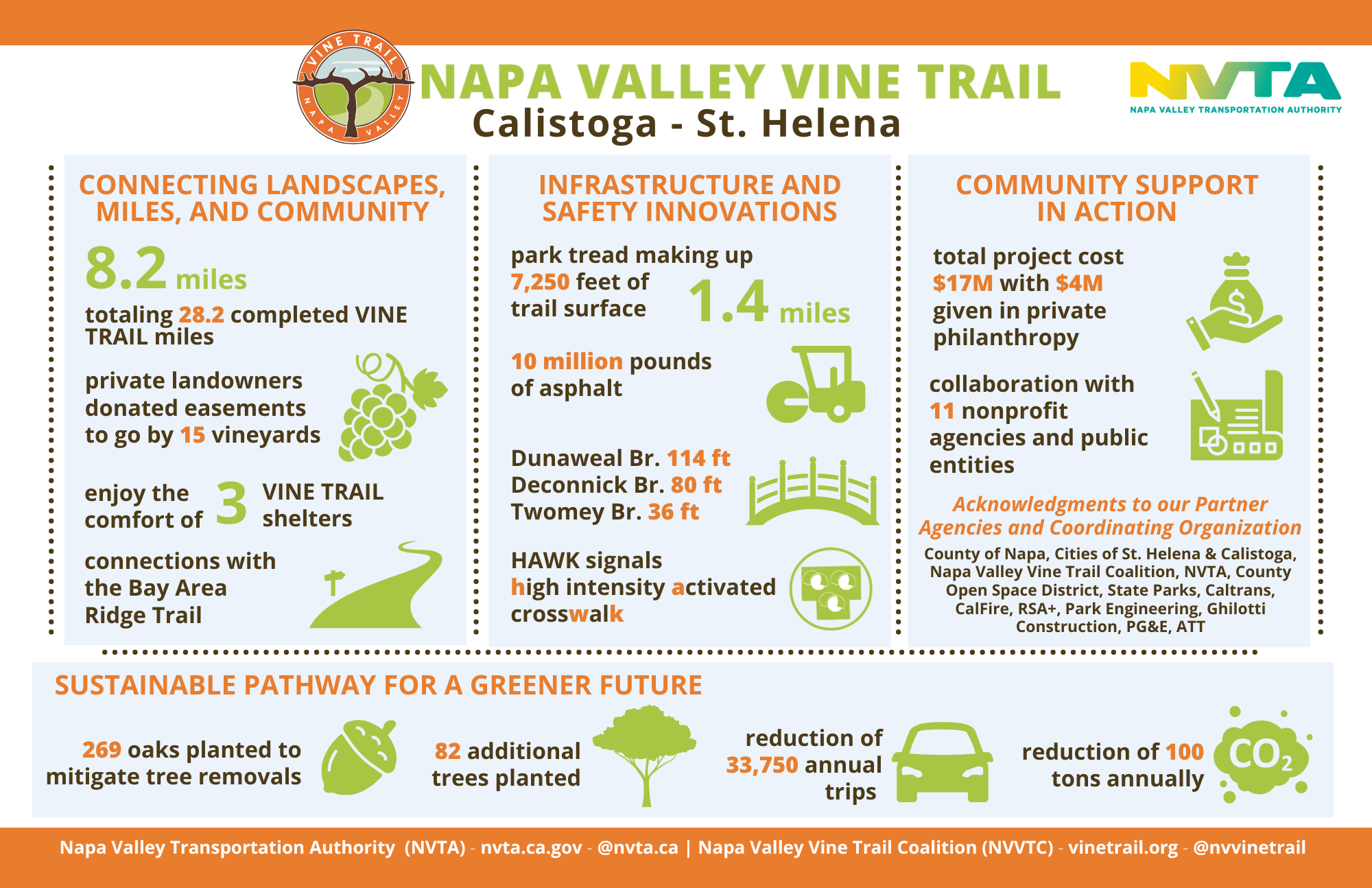
Vine Trail grows 8.2 miles from Calistoga to St. Helena – official opening Aug. 17, 2024
Once completed, the Napa Valley Vine Trail will span 47 miles, connecting five cities, one town and two counties, from Calistoga to Vallejo, with a paved, Class 1 multimodal pathway. The newest stretch runs from Pratt Avenue in St. Helena to Lincoln Avenue in Calistoga, covering 8.2 miles of vineyards and world-class wineries, while winding through the picturesque Bothe-Napa Valley State Park and Bale Grist Mill State Historic Park.
“This project required the hard work of so many — I am proud of NVTA staff and our many partners for bringing this project to the public,” said Kate Miller, Executive Director of the Napa Valley Transportation Authority, which took the lead in building this section of Vine Trail. “We hope residents and visitors from St. Helena to Calistoga, and around the Valley, can enjoy this trail for generations to come.”
The new trail will open to the public on Saturday, Aug. 17, during a community event sponsored by the Napa Valley Vine Trail Coalition. The public is invited for a morning of music, meet-up rides, prizes, and exploration. More information and a schedule of events can be found at the organization’s website.
“We are witnessing a dream become reality,” said Shawn Casey-White, Executive Director of the Napa Valley Vine Trail Coalition. “Fifteen years ago, vintner Chuck McMinn brought together a coalition of the Napa Valley Vintners, Napa Valley Land Trust and the Napa Valley Grapegrowers to build an alternative corridor for a safer, more sustainable future for Napa Valley. This important section is the result of that vision and commitment of landowners, coalition members, and government officials.”
The surface of the new trail consists primarily of asphalt, but includes 1.5 miles of Park Tread, made from quarried shale/chert so it is both natural and durable — a perfect material in sensitive areas like wetlands and vineyards. Park Tread has been used in Golden Gate Park and Yosemite National Park.
With an overlapping footprint, the new section of the Vine Trail also adds 4.2 miles to the Bay Area Ridge Trail.
At a total cost of $19.1 million, the Calistoga to St. Helena section was largely publicly funded by the Active Transportation Program of the California Transportation Commission, the Metropolitan Transportation Commission’s One Bay Area Grant 2 Program (Regional) and other state and local funding. Through the nonprofit Napa Valley Vine Trail Coalition, community donors and private philanthropy gifted significant funds and easements to the project. Finical contributions were also made by the County of Napa, the Cities of Calistoga and St. Helena, and the Napa Valley Transportation Authority. Fifteen private landowners donated easements to ensure the trail could be built.
“The Vine Trail is one of Napa Valley’s most prized projects, and this newest section will encourage residents and visitors to get outdoors to take in our natural beauty,” said Mark Joseph, NVTA Board Chair and American Canyon City Councilmember. “I am also proud to see the progress underway on the segment that connects American Canyon and Vallejo.”
The new trail generally follows the State Route 29 corridor. That means it is dotted with bus stops, making it easy to access by public transit – visit vinetransit.com for schedules and routes. Projects like the Vine Trail help Napa Valley become less car dependent, increasing public opportunities to get active and outdoors. Existing sections of the Vine Trail from the City of Napa to the Town of Yountville are used by local residents 70% of the time, compared to 30% by visitors, indicating a high level of adoption by the local community.
Meanwhile, the Vine Trail continues to grow. Construction on the 5.5-mile segment that connects American Canyon and Vallejo will be completed this fall. The 11-mile stretch from St. Helena to Yountville is now in the planning stages.
Newest Vine Trail section nearing completion
 With 8.2 freshly paved miles of pathway for pedestrians and cyclists, the newest segment of the Napa Valley Vine Trail – opening this summer – will connect the cities of Calistoga and St. Helena. Bending through the beauty of Bothe-Napa Valley State Park and past rolling hills of heritage vineyards, this newest public path is shaping up to be one of the most picturesque of the 47-mile Vine Trail.
In partnership with more than a dozen agencies, the Napa Valley Transportation Agency (NVTA) took the lead on this nearly $17 million project, which was funded largely by state dollars, $6.1 million from the Active Transportation Program funds and $2.9 million in Metropolitan Transportation Commission’s OneBayArea Grant funds. Local jurisdictions also made this dream project a reality, thanks to $3.1 million from the Napa Valley Vine Trail Coalition, $1.3 million from the County of Napa, $594,000 from the City of Calistoga, $593,000 from the City of St. Helena and $150,000 from the California Coastal Conservancy. It would not be possible without the contributions of 15 local landowners, who allowed the trail to cut through their properties for the good of the public.
Thanks to an overlapping footprint, the new segment of Vine Trail allowed the Bay Area Ridge Trail to expand its connectivity in the North Bay, inching 4.2 miles toward its goal to build a 550-mile trail that loops from San Jose to Mount St. Helena.
To celebrate the Grand Opening of this new public treasure, the Napa Valley Vine Trail Coalition has planned a community celebration on Saturday, August 17, from 8 a.m. to 12 p.m. Look to vinetrail.org for more details on the public trail party coming soon.
Update: May 2024
Summer 2024 opening for Calistoga to St. Helena section!
After an especially wet rainy season delayed construction, the 9-mile Vine Trail section between St. Helena and Calistoga is nearing completion. HAWK Pedestrian Signals are being installed to ensure safe crossing along SR-29, park tread will soon be laid and all the final details are falling into place. Come summer, this Class I trail will be ready to welcome cyclists and pedestrians for a smooth trip through Up Valley.
Look for details of the official opening celebration, coming soon.
In other Vine Trail news, the section from Vallejo to the Napa County line is now under construction; and planning and environmental work is underway for the segment from Yountville to St. Helena.
Scroll down for more history on this transformative, 47-mile infrastructure partnership that will span Calistoga to Vallejo once completed.
Want to know more about what this section of the Vine Trail will be like? Here are some fast facts:
🚴 🏃 🚶
Earlier updates
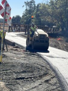
Winter, 2024: Construction crews are hard at work to get this section ready for public use.
This section, from Pratt Avenue in St. Helena to Washington Street in Calistoga, remains under construction. Please stay off of this portion of the Vine Trail for your own safety. There are plenty of other places to ride, walk, or run, such as the 12-mile segment of the Vine Trail from Yountville to Napa!
July 25, 2022: Ghilotti, the contractor, has completed grading in Calistoga. They are now working on Dunaweal Lane Bridge and State Route 29 between Dunaweal Lane and Larkmead Lane. NVTA is coordinating its work with the PG&E gasline replacement, Caltrans repaving, and other local projects in order to minimize disruption.
July 5, 2022: There were shovels in the ground starting in Calistoga on Fairway Drive behind the Calistoga Depot.
June 30, 2022: Construction on the Vine Trail started with surveying and staking.
May 24, 2022: NVTA and transportation leaders broke ground on Vine Trail construction.

🚴🏃🚶


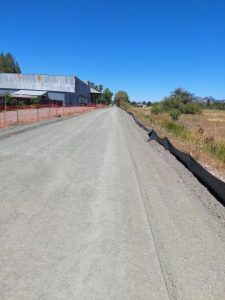
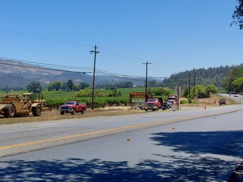
Recent Photos of Vine Trail Construction from St. Helena to Calistoga. (Photo credit: Thomas “TC” Hurley)
THE NAPA VALLEY VINE TRAIL
The Napa Valley Vine Trail is a walking and biking trail connecting the entire Napa Valley. When completed this 47-mile trail will be the key link in Napa County’s county-wide trail system which also includes portions of the region-wide Bay Trail and Ridge Trail. Detailed planning for the Napa Valley Vine Trail was started by the Napa County Transportation and Planning Agency when, in 2007, they commissioned The Greenway Feasibility Study. This Study was completed in 2008 and formally accepted by NCTPA (Now NVTA) in March 2009.
Its conclusion was that a Class I trail (separated from the roadway) on the Valley floor was feasible and should be pursued. The non-profit Napa Valley Vine Trail Coalition, a unique partnership, made up of 27 of the county’s most influential non-profit and government groups was formed to implement the Class I Multi-use Path the full length of Napa Valley.

THE ST. HELENA TO CALISTOGA SEGMENT
The Napa Valley Vine Trail – St. Helena to Calistoga project is a 9-mile Class I bicycle and pedestrian trail within St. Helena and Napa County. The Napa Valley Vine Trail – St. Helena to Calistoga project would be located within California Department of Transportation (Caltrans) right of way (ROW), State Park lands, existing easements, and easements to be granted from property owners. The St. Helena to Calistoga project would begin in St. Helena at the intersection of Pratt Avenue and State Route (SR) 29 at postmile (PM) 29.244 and extends to the north end where it would terminate at Dunaweal Lane east of SR 29 at PM 35.308 near the city limits of Calistoga.
The proposed path would be 10-feet wide with 2-foot shoulders for a total width of 14 feet in most locations, narrowing to a lesser width (minimum 8 feet) in constrained locations. In most locations the Vine Trail would be an asphalt trail installed over aggregate base, with gravel shoulders. With exception of a portion of Vine Trail through Bothe-Napa Valley State Park, most of the proposed Vine Trail would be on the east side of SR 29. Most of the Vine Trail would be separated from SR 29, though a few portions of the proposed Vine Trail would occur on the shoulder of SR 29.
An additional segment called the Fair Way Path Extension would be constructed at the same time as the proposed project. The Fair Way Extension would be a 0.6-mile Class I trail that extends north from an existing segment of the Napa Valley Vine Trail, from Washington Avenue in Calistoga to the intersection of Fair Way and Lincoln Avenue in Calistoga (east of SR 29 and approximately between PM 36.45 to 37.22). The Fair Way Path Extension was previously analyzed under CEQA and a Mitigated Negative Declaration has been approved by the City of Calistoga’s Planning Commission (PC Resolution 2014-29; November 26, 2014).
Mitigated Negative Declaration
The NVTA Board of Directors held a Special Meeting on Wednesday August 19, 2020. The Board approved the California Environmental Quality Act (CEQA) Mitigated Negative Declaration for the Napa Valley Vine Trail St Helena to Calistoga Section. The final documents are available at the links below:
- CEQA Initial Study/Mitigated Negative Declaration Napa Valley Vine Trail: St Helena to Calistoga Section
- Mitigation Monitoring and Reporting Program
Project Construction
NVTA released an Invitation to Bid for the St. Helena to Calistoga Segment on December 23, 2021. A total of seven bids were received on February 2, 2022. NVTA is in the process of reviewing the bids received and is working to award the construction contract and start construction in the Spring of 2022.
THE OAK KNOLL SEGMENT
CLICK HERE TO READ THE OAK KNOLL SEGMENT FACT SHEET
NVTA secured nearly $7 million in state and federal funds for the 6-mile stretch of Vine Trail linking Napa to Yountville along Solano Avenue, a project totaling about $10 million. NVTA is project sponsor for the Oak Knoll segment, a unique collaboration between the private Napa Valley Vine Trail Coalition, local agencies and Caltrans. With the Oak Knoll Segment finished, 12.5 miles of Class I paths are now available for bicyclists & pedestrians to travel safely between Napa and Yountville. When complete, the Vine Trail will be a 47-mile path linking the Napa Valley from Calistoga to the Vallejo Ferry Terminal.
- Planning
- Environmental
- Design
- Construction
- Completion
Highway 29 – American Canyon Improvements
The proposed improvements would address traffic flows, transit access, multimodal infrastructure and aesthetics.
Soscol Junction Interchange Project-Napa County
Soscol Junction at SR 29, SR 221 and Soscol Ferry Road, is now open and improving traffic flows in Napa County!
Vine Transit Maintenance Facility
The state-of-the-art Vine Transit Maintenance Facility, completed in March 2024, includes the equipment needed to support the future of sustainable transportation, such as hydrogen technology.
Napa Valley Forward
NVTA is collaborating with the Metropolitan Transportation Commission (MTC) on the Napa Forward program that will make improvements on SR 29 in Oakville.